I’ve been meaning to get down to the Ecrins all summer, and so when Matt suggested a spontaneous trip straight from the Vanoise, I didn’t take much convincing. Like all climbers in the Alps, we’d both always wanted to climb the Meije so we decided against acclimatising and got straight on it. Approaching the Promontoire Refuge from La Berarde took nearly 4 sweaty hours, but it could have been much quicker had we not taken numerous 20 minute swimming breaks on the way up.
The hut is pretty spectacular, poised right underneath the Promontoire ridge and S face of the Meije. It is also pretty small so it feels much nicer than being in one of the huge huts in the more accessible parts of the Alps.
View from the hut heli deck.
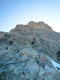
Looking up at the route from the start point
With Tuesday being the first day forecast to be clear of thunderstorms, the hut was surprisingly quiet, and there was only us and 2 other parties going for the traverse. The other teams got away at 4.30, and we were 15 minutes behind (you can’t rush these things!) but we never saw them again as one of them was a Guide who clearly knew the route like the back of his hand, and the other team followed him shamelessly!
Matt's dress sense is best viewed in the dark.
At the Dalles Castelnau
Matt just below the Carree Glacier.
The route finding is actually ok on the lower ridge, you just climb the crest until it steepens dramatically and then traverse left into a big couloir which leads you up the Dalles Castelnau area. From there it becomes slightly harder as you have a big rightwards traverse followed by one straight back left. We started looking for the traverse back left too early, so just remember to keep traversing right until you can almost touch the water streaks coming down from the Carree Glacier and you’ll see the ledge system leading back left. Once back on the main ridge you follow the crest, taking the easiest line up to the Carree Glacier.
Exiting the Carree
Looking up at the final summit ridge. We climbed up the deep groove on the right and then drifted back left before heading back right for the final steep wall. Its all pretty steady really so just follow your nose.
Matt on the final summit ridge
The Carree is given 30 minutes to an hour in the guidebook but I’m not quite sure how it would take that long as we were up it in 15 minutes of plodding. From there it is just a case of scrambling up very easy terrain to the ridge crest just below the summit and then there is 15 very exposed metres to the top. The summit is amazing – just views everywhere, and a nice little statue of Jesus to pose with!
Giving Jesus a peck on the summit!
And a piece of cake!
Looking along the traverse from the top of the Grand Pic
To get down you go to a block with loads of abseil tat around it in the direction of the rest of the Meije ridge and then downclimb about 5 metres to a bolted abseil point, and then 3 abs get you down.
The ridge line from there is easy to follow and straightforward enough that you can safely move together the whole way, apart from a section below the first point which is a 70 degree ice gully, thankfully equipped with a metal cable to pull on. There were some sections where the cable disappeared though, which made for some fairly spicy climbing with a ski touring axe and bendy B2 boots. The ridge is spectacularly exposed and in an amazing situation, so the easy climbing is great as it allows you to take it all in without too much stress.
Typically exposed climbing just below the Grand Pic
The icy section - character building with bendy boots and a lightweight ski touring axe.
Matt downclimbing on easy but exposed ground.
Looking back to the Grand Pic from near the end.
We made good progress along the ridge and were soon on top of the Doigt de Dieu, which marks the end of the Meije peaks. The descent from there down to the Aigle hut is simple enough but with hindsight I would downclimb most of it as we abbed too much and got the ropes caught a couple of times.
The traverse seen from the descent
From the Aigle it is then a simple (!) case of walking for 3 hours down to La Grave and then hitching back to La Berarde, which was frankly epic. We luckily got picked up for the final leg to La Berarde at after 10pm, and with hindsight I would stay in La Grave instead of risking not getting picked up and ending up in the middle of nowhere for the night. After a very comfortable night in the van we had a much needed coffee and then headed home to Cham via a swim in the lake at Passy.
Both of us agreed that the traverse was absolutely superb and despite the enourmous walk down to La Grave, it was one of the best days we had had all year. The climbing is easy, the route finding is not too bad, and the situation incredible. The guidebook time is 10 – 12 hours and this seems about right. We were unacclimatised and came in at 10.5 hours by just keeping up a steady, unspectacular pace and keeping hydrated and well fed.
Gloves vs. Meije - no contest.
What a route.


